14 Johnson Lake

Johnson Lake
This is a shorter, alternate trail to Johnson Lake and the Johnson Mine historic site. The scenic trail climbs though quaking aspen groves and through cool alpine forest to the arctic-alpine tundra zone above timberline.
- Distance: 7.4 miles out-and-back; long dayhike or two day backpack trip
- Time: 6 hours or two days
- Difficulty: Strenuous
- Elevation change: 8,320 to 10,760 feet
- Season: Summer and fall
- Permits: Day hikers are requested to sign in at the trailhead, if a register is available. Backpackers are encouraged to voluntarily register at a park visitor center
- Water: Snake Creek, Johnson Lake
- Maps: USGS: Wheeler Peak
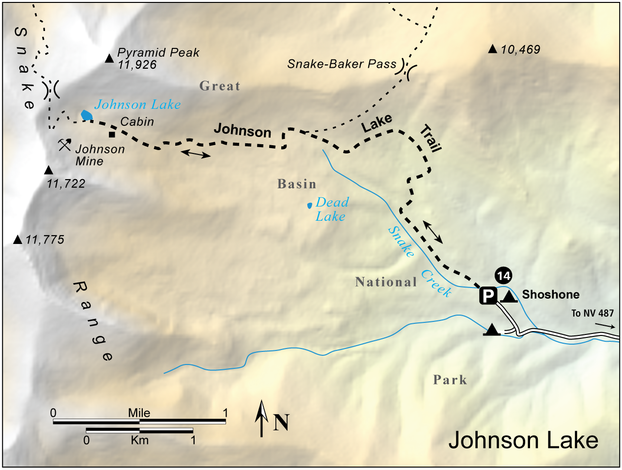
- Finding the Trailhead: From Baker, drive south 5.2 miles on NV 487, then turn right (west) on the signed, graded Snake Creek Road. Follow this road 13 miles to its end. (There are several primitive campsites along the road.) Just before the end of the road, a jeep road goes left- stay on the main road. The trailhead has a primitive campground with picnic tables, in a fine aspen grove surrounding Snake Creek. UTM: Zone 11 737958mE 4312437mN
Key Points
- 0.0 Snake Creek Trailhead (UTM: Zone 11 737958mE 4312437mN)
- 2.4 Trail to Snake-Baker Pass; stay left (UTM: Zone 11 736236mE 4313903mN)
- 3.7 Johnson Lake (UTM: Zone 11 734442mE 4313850mN); return the way you came
- 7.4 Snake Creek Trailhead (UTM: Zone 11 737958mE 4312437mN)
The Hike
The Johnson Lake Trail follows an old jeep trail which is closed to vehicles. It is not marked or maintained, so you should have the topographic map. Start from the upper end of the parking lot and follow the unsigned old road directly up the hill. After a few hundred yards another jeep road comes in from the left, and the trail turns right and crosses Snake Creek. It stays north of Snake Creek all the way to Johnson Lake. After crossing the creek, the trail parallels it on the right, climbing through alpine meadows bordered with aspen and white fir.
The forest type in the Snake Range is well-represented along the Johnson Lake Trail. Great Basin trees such as curl-leaf mountain mahogany grow next to Rocky Mountain white fir and Engelmann spruce. Douglas fir is also common, as is limber pine. Along this section of the trail you should be able to identify white fir by its flat needles which will not roll in your fingers, and its spongy, cork-like bark. The needles of Douglas fir are similar but the bark is gray and more deeply furrowed. Limber pine has two inch long needles growing five to a bunch, and the limbs are very flexible, helping the tree to survive heavy alpine snow loads.
After following the creek for a while, the trail veers away to the north and descends to cross a drainage. It then climbs out onto a sage-covered slope which it ascends in a couple of switchbacks. Notice the contrast between this dry south-facing slope, covered with sage and mountain mahogany, and the moist north-facing slope you just descended, which is covered with fir and aspen.
Above the switchbacks, the trail climbs steeply through forest in which limber pine starts to appear. You will also see Engelmann spruce, whose needles grow singly like the firs, but are square in cross section so that they roll easily between your fingers. You may notice a faint trail which goes right. This trail climbs to the Snake-Baker Pass; stay left on the Johnson Lake Trail. The trail now heads a minor drainage in the forest and climbs onto a point where the forest takes on a decidedly more alpine appearance. There are a number of campsites here but no water after the snow melts. In another half mile the trail passes an old cabin. There are a few campsites here and there is water in the creek. Be sure to camp at least 100 feet from the water.
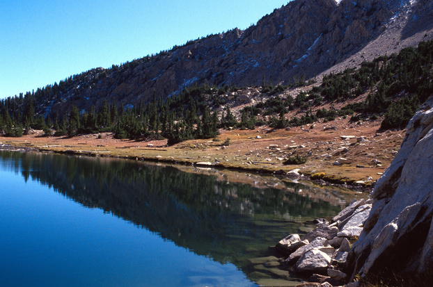
After the cabin the old road becomes rougher and steeper for about a half mile, then moderates a bit for the final climb to the lake. More cabins, one of them fairly elaborate, are located just below the lake. Various cut logs and rusty pieces of equipment are strewn around the cabins and the lake, indicating that a lot of activity took place here. There is even a cable strung from one of the mines high on the talus slope. Some of the cut timber might have been used to support a tramway. The lake itself is small, but the west end is deep. It is a true alpine tarn- a lake created by a glacier.

