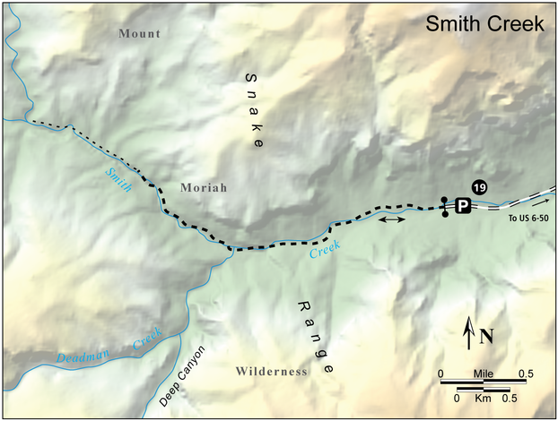
19 Smith Creek
The trail takes you into a remote canyon on the north side of the Mount Moriah Wilderness which features interesting limestone caves and cliffs. It also offers potential cross-country access to The Table and the long, deep canyons draining The Table's north slopes.
- Distance: 4.2 miles out-and-back
- Time: 4 hours
- Difficulty: Moderate
- Elevation change: 5,880 to 6,440 feet
- Season: Spring, summer, and fall
- Permits: None. Hikers should leave word of their hiking plan with a reliable person
- Water: Smith Creek
- Maps: USGS: Mount Moriah, Little Horse Canyon; USFS: Mount Moriah Wilderness
- Finding the Trailhead: From Baker, drive 5.0 miles northwest on NV 487, then turn right (east) on US 6-50, and almost immediately, take the next left (northeast.) The correct road goes past a small electrical substation. Stay on this road, which becomes maintained dirt as it heads northeast across Snake Valley, for 10.9 miles to a crossroads. Continue straight ahead on the main road to a small ranch 26.9 miles from US 6-50, then turn left on the signed Smith Creek road. Follow this non maintained dirt road 7.1 miles to its end. There are a couple of rough creek crossings near the end of the road, and their condition changes from year to year. If necessary, park and walk the last part of the road. The road is closed at the trailhead, which is the wilderness boundary. Smith Creek has water, and there’s limited camping (with shade) at a small site a hundred yards before the trailhead. UTM: Zone 11 748787mE 4357884mN
Key Points
- 0.0 Unsigned trailhead at the wilderness boundary (UTM: Zone 11 748869mE 4357876mN)
- 1.3 Deadman Creek (UTM: Zone 11 746898mE 4357449mN)
- 2.1 Trail fades out (UTM: Zone 11 745790mE 4358213mN); return the way you came
- 4.2 Unsigned trailhead at the wilderness boundary (UTM: Zone 11 748869mE 4357876mN)
The Hike
The unsigned trail up Smith Creek gets very little use. It starts as an old jeep trail and soon climbs away from the creek on the north, providing an open view of the impressive canyon. Then the trail crosses the creek and enters a cottonwood grove. Deadman Creek enters noisily from the left (south) as it pours over a series of ledges. Continue up Smith Creek on the now much fainter trail. Since it was built as a jeep road, the trail always crosses the creek when the bench peters out. The canyon becomes gradually narrower, and the high cliff on the north side is especially impressive. There are also tantalizing views of the high country, far above to the south. About 2.1 miles from the trailhead, the old trail drops into the bed of the creek and fades out. Our hike ends here, but experienced hikers can continue to Ryegrass Canyon. Other exploration possibilities are Deadman Creek and its several tributaries.

