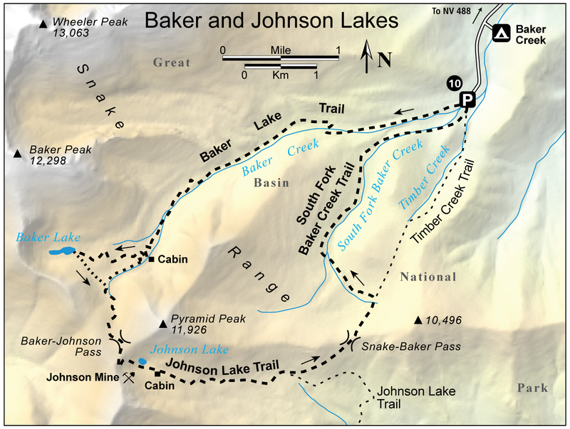
10 Baker and Johnson Lakes

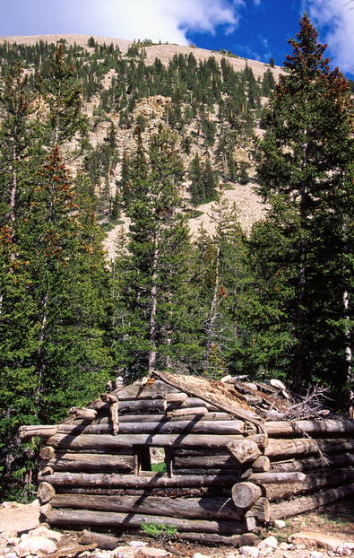
Old cabin on the Baker Creek Trail
This is an especially scenic loop hike that follows a cascading alpine creek to a pair of classic alpine lakes. It also crosses two high passes and traverses alpine meadows with open views of the surrounding summits. You'll also pass by the site of an historic tungsten mine.
- Distance: 13.1-mile loop; long dayhike or overnight backpack trip
- Time: 10 hours or two days
- Difficulty: Strenuous
- Elevation change: 8,000 to 11,300 feet
- Season: Summer and fall
- Permits: Day hikers are requested to sign in at the trailhead, if a register is available. Backpackers are encouraged to voluntarily register at a park visitor center
- Water: Baker Creek, Baker Lake, Johnson Lake, South Fork Baker Creek
- Maps: USGS: Wheeler Peak, Kious Spring
- Finding the Trailhead: From Baker, drive west 5.2 miles on NV 488, the entrance road to the park. Just after passing the park boundary sign, turn left (south) on the signed, maintained dirt Baker Creek Road. Follow this road 4.0 miles to its end at the signed Baker Trailhead. UTM: Zone 11 738613mE 4317778mN
Key Points
- 0.0 Baker Trailhead (UTM: Zone 11 738613mE 4317778mN)
- 4.1 Old cabin
- 4.3 Junction with Baker-Johnson Trail (UTM: Zone 11 733218mE 4315507mN)
- 5.3 Baker Lake
- 5.5 Cross-country route to Baker-Johnson Trail (UTM: Zone 11 733495mE 4315351mN)
- 5.9 Baker-Johnson Trail; turn right (UTM: Zone 11 733670mE 4315027mN)
- 6.4 Baker-Johnson pass
- 7.1 Johnson Lake
- 8.7 Junction with trail to Snake-Baker Pass; turn left (UTM: Zone 11 736238mE 4313917mN)
- 9.4 Snake-Baker Pass
- 10.0 Junction with S. Fork Baker Creek Trail; turn left (UTM: Zone 11 737430mE 4315131mN)
- 12.8 Junction with Timber Creek Trail; turn left (UTM: Zone 11 738567mE 4317592mN)
- 13.1 Baker Trailhead (UTM: Zone 11 738613mE 4317778mN)
The Hike
Start on the Baker Lake Trail. The trail climbs along the north side of boisterous Baker Creek, sometimes swinging to the north in a series of switchbacks. There are varied views of the canyon walls and the high country, especially when the trail temporarily leaves the creek and its dense riparian vegetation. Other sections of the trail stay near the creek in fine aspen groves. After a long climb, the trail passes the ruins of an old cabin. It was probably used by Peter Deishman, a prospector who was active in the early part of the century. Continue on the main trail which climbs the steep slope below Baker Lake in a series of switchbacks. Watch for a faint, unsigned trail going left to Baker-Johnson pass, but stay right on the main trail and continue to Baker Lake. This small, scenic alpine lake is backdropped by the rugged cliffs of the Snake Range crest and Baker Peak.
After enjoying the lake, start back down the trail and watch for a cairned cross-country route going right (southeast) before the main trail starts its steep descent. Follow the cairns as they contour southeast a short distance to join the faint Baker-Johnson trail in the open valley above timberline. If you don’t find the trail along the creek, just follow the drainage and the cairns uphill. The route finally reaches Johnson Pass at 11,294 feet. There are sweeping views, including Baker Peak, Jeff Davis Peak, and close at hand, Pyramid Peak.
Look for a few cairns and follow them south from the pass. The trail becomes well defined on the steep slope below the pass. Early season hikers will have to avoid one or more steep snowfields. If the trail is lost under snow, pick it up farther down the slope. It soon joins a much better (but still little-used) trail which goes right (southwest) to the old Johnson tungsten mine, established by Alfred Johnson in the fall of 1909.
Turn left, downhill, and continue to the south shore of Johnson Lake. You’ll pass more relics of the old mine, including an aerial tram cable spanning the talus slope up to the mine. Timbers and other old mining gear are scattered along the east shore of the lake, apparently brought down by a major snow avalanche in 1935. This event destroyed most of the mine workings and put an end to an already marginal venture.
The trail, now an old jeep road, continues down the drainage east of the lake and gradually becomes more distinct. Watch for the ruins of several old cabins used by the mining operation. There are numerous good camping spots in this area and water is available in the creek. The trail descends steeply after the cabins. About a mile below Johnson Lake, the trail passes the ruins of the old Johnson mill, a large log structure. Ore was brought down to Johnson Lake via the aerial tram, then transported on mules to the mill. After being concentrated, mules carried the tungsten ore on down the mountain and eventually to the railhead at Frisco, Utah. Transportation costs would have been high, which probably contributed to the closure of the mine.
There is more camping in the forest below the mill on the south side of the trail though you'll have to carry water down from the creek. About 0.3 miles after the mill, you’ll pass an old road closure gate; this is the signal to start watching on the left for the trail to the Snake-Baker pass. The foot trail is little-used and easy to miss. It climbs steadily through aspens to reach the pass, where the trail becomes faint. Turn left (north), and descend the trail to the northeast through the forest below the pass..
Ater a short distance the trail emerges into a broad meadow. A wide pass is visible above to the right. Follow the faint trail across the meadow toward this pass. Just as it starts to climb, a sign points out the South Fork Baker Creek Trail to the left and Timber Creek Trail ahead, over the pass. Turn left (west) and descend the faint South Fork Baker Creek Trail down the meadow into the South Fork. (This junction is shown incorrectly on the USGS map.) You’ll pick up the trail again as it nears the right side of the creek where it enters the trees. From the junction, it’s about 2.6 miles to the junction with the Timber Creek Trail. Turn left and cross three bridges across Baker Creek to reach the Baker Trailhead.

