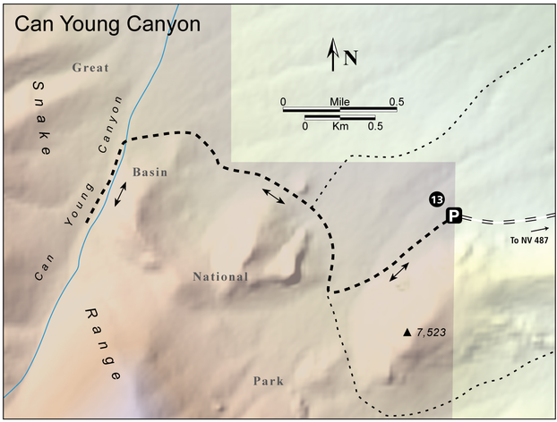
13 Can Young Canyon
This is a moderate, low elevation hike to a scenic foothills canyon which has brilliant color in the fall. It is also a good choice in the spring when higher trails in the Snake Range are still snow-packed.
- Distance: 4.8 miles out-and-back
- Time: 4 hours
- Difficulty: Moderate
- Elevation change: 6,480 to 7,200 feet
- Season: Spring, summer, and fall
- Permits: Day hikers are requested to sign in at the trailhead, if a register is available. Backpackers are encouraged to voluntarily register at a park visitor center
- Water: Can Young Canyon
- Maps: USGS: Kious Spring
- Finding the Trailhead: From Baker, drive 1.0 miles southeast on NV 487, then turn right on a maintained dirt road. The road goes past a large water tank. When 2.4 miles from the highway, turn right onto an unmaintained road, which requires a high clearance vehicle. Go right at a minor fork 2.7 miles from the highway, and continue to the park boundary at 3.5 mile. It’s advisable to park here, as the road becomes much rougher ahead. UTM: Zone 11 745189mE 4317752mN
Key Points
- 0.0 Unsigned trailhead at the park boundary (UTM: Zone 11 745189mE 4317752mN)
- 0.7 Tee junction at water trough; turn right (UTM: Zone 11 744294mE 4317208mN)
- 1.1 Junction below saddle; stay left (UTM: Zone 11 744189mE 4317775mN)
- 2.1 Can Young Canyon; turn left (UTM: Zone 11 742770mE mN)
- 2.4 End of hike (UTM: Zone 11 742598mE 4317612mN); return the way you came
- 4.8 Unsigned trailhead at the park boundary (UTM: Zone 11 745189mE 4317752mN)
The Hike
From the park boundary, walk up the road. The road is seldom used and it makes a nice hike. You’ll have a good view of the impressive cliffs to the left of the road. The road reaches a T intersection at a cattle watering trough in Kious Basin. Turn right, downhill, and follow the old road as it swings around another impressive cliff. A road forks right; turn left, uphill to the northwest. Within a few yards the road goes over a saddle formed by a large rock knob. Shortly after leaving the saddle, the road goes through a gate, temporarily leaving the park. After this, the road climbs slowly along the foothills, then climbs more steeply into the mouth of Can Young Canyon. Cross the flowing creek, then, at another T intersection, turn left and walk past the park boundary sign into the canyon. The road is closed to vehicles at this point. The old road continues along the creek, past fine aspen stands, before fading and becoming blocked by deadfall. This makes a good turnaround point.

